Houston Radar › Support Forum › Product Support FAQ › Armadillo Tracker Speed and Volume Collector Support › How does the GPS option function in the Armadillo Tracker?
Tagged: Armadillo Tracker GPS
-
AuthorPosts
-
The Armadillo Tracker features a GPS “geolocation” option that may be ordered as part of the unit. When ordered, we install a custom low power GPS receiver into the Tracker. This device will acquire the GPS coordinates where the data was collected and save this along with the data into non-volatile memory.
Subsequently when you import the data into our Stats Analyzer program for analysis (or when the data is uploaded to our Tetryon Cloud Server), the GPS coordinates are imported along with the data and these coordinates are displayed on a Google maps in the project.
This feature makes it foolproof to determine where the data was collected. The GPS receiver has sufficient resolution to identify, not only the general location of the data collection point, but also which side of the road the unit was installed.
Function Details of the GPS Option are described below:
On power up, the Armadillo Tracker tries to acquire GPS coordinates for the first 15 minutes. If a good GPS fix is acquired (i.e. a “3D” fix and a decent HDOP), it will turn OFF the GPS controller and cache the GPS fix. This GPS fix is also recorded in non-volatile memory along with acquired traffic data.
If it cannot get a good fix within the first 15 minutes, it will shut down the GPS controller and no coordinates will be reported or logged. This is done to save power and increase the run time of the Tracker. Unlike a Mobile Phone, the Tracker does not leave the GPS controller powered ON and does not continually acquire GPS coordinates, hence it has no way of knowing that it has been moved. Thus to acquire GPS coordinates, power cycle the Armadillo Tracker with the provided key.
GPS receivers are also affected by tall buildings/trees etc. So, at a new location, it is recommended to power ON the Radar once it has been installed on the Pole.
Monitoring GPS Acquisition Progress/State:
If you have a modem equipped Armadillo Tracker (which also always has GPS module) we recommend using our Android App (Available for free in the Android Play store) or the iPhone App (available free in the Apple App Store- Purchase of Apple MFI connectivity module in Tracker required for iOS connectivity) to monitor the GPS progress.
Connect to the device via Bluetooth and navigate to the Radar Info menu. If the Modem with GPS is present you will be presented with the screen that looks like the screen shot below. Periodically click on the “Refresh” button (circled) to get the latest status from the device.
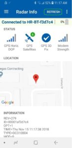
If you have just a GPS enabled Armadillo Tracker you can still go the “Radar Info” screen but you will only be presented with text output. Non zero GPS coordinates will be listed as one of the text line if it has acquired a fix.
If you are connecting via our Windows Stats Analyzer program, the info box that pops up on first connection will have the GPS coordinates listed as non-zero values.
-
AuthorPosts
- You must be logged in to reply to this topic.